Mar 29, 2022
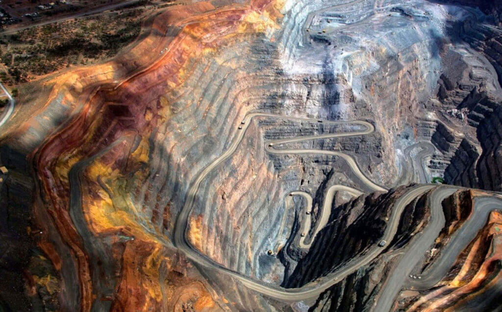
In early 2022, record rainfall of 140 mm contributed to a slope failure at a mine in South America that shut down production and blocked local roadways. Fortunately, no loss of human life occurred, and environmental impact was limited as the reservoir dam contained much of the debris flow.
When situations like this occur, it is useful to reflect on what approaches mine owners and operators can take to continue to improve risk mitigation. In this post, we examine what kind of factors can contribute to similar outcomes and what sort of monitoring strategies can be used to help mining stakeholders mitigate the risk of slope failure from occurring.
Slope failure, like many geohazards, has a complex number of factors and causes that can come together to cause catastrophic outcomes. Generally, slope failures occur when a driving force—gravity, for example—overcomes a resisting force, like the slope material’s shear strength.
Geology, soil type, vegetation, freeze/thaw cycles, human activity, slope angle, saturation and pore pressures can all contribute to slope failure.

A holistic approach to risk mitigation reduces both the probability of slope failure events from occurring while also providing stakeholders with better information that can be used to form the foundation of their trigger action response plans (TARPs). This type of approach allows engineers the ability to better predict and mitigate risk during the design phase, construction, operation, maintenance, and closure and post-closure activities.
Owners and operators of mines must consider the framework of why risk mitigation matters. They have moral, legal and environmental obligations to consider, as well as the economic motivation for adopting a proactive approach to risk mitigation.
Mine owners and operators have a responsibility to identify the hazards, analyze the probability of occurrence, along with the severity of consequences, then calculate a factor of safety. Owners and operators can also look to the recent publication of the Global Industry Standard on Tailings Management for guidance on the expectations of safer practices.
Engineering projects, products, and designs must be developed with the primary objective of maintaining the well-being of the public. Due diligence is not only the right thing to do—it’s also the professional thing to do.
There is a strong legal mandate for good risk management practices in engineering projects. Due diligence is required by the courts of the state, which requires a commitment to best practice.
Owners and operators of mines have an obligation to conduct business in a manner that impacts the environment as little as possible. Demonstrating a commitment to limiting a company’s environmental footprint and acting as a responsible steward of nature is important to maintain a company’s reputation in the international business community. Especially as more and more companies pledge to uphold environmental, social, and governance (ESG) criteria to appeal to socially-conscious investors.
Peter Drucker, an influential thinker on management concepts, said that the first duty of business is to survive. Therefore, the guiding principle of business economics is not the maximization of profit—it is the avoidance of loss. This makes risk management a key pillar of doing business.
Effective risk management helps companies avoid major losses. Proper risk mitigation minimizes:
· Loss of life and injury to employees and contractors
· Damage to property, equipment, and other assets
· Loss to process or production
· Regulatory fines and legal costs
· Costs of incident investigation
· Implementation of remedial measures
Potential loss of market share until the company’s reputation is restored.
Instrumentation and the analysis of the data collected provide a reliable method to verify assumptions made early in the design process, to establish a quantifiable, measurable and reportable method of oversight throughout all phases of an engineering project —whether during the design phase or during operation.
Data must provide a meaningful overview of the geotechnical response in mining as well as the day-to-day activities. Data that is the most current and easy to share and report is going to be the most useful to base decisions on. Automated data collection and modern data visualization software can give mining stakeholders a better and more centralized method to view timely and actionable data.
Interferometric Synthetic Aperture Radar (InSAR) compares multiple radar (SAR) image pairs to detect and measure displacement over time. Interferograms are then created based on the comparison of the phase information from a set of SAR images. This difference in the wavelength’s phase position denotes the amount of displacement that took place between the image acquisition dates, which could be as often as every few days. InSAR monitoring can detect subtle changes in the ground surface, which can alert operators to areas of interest. InSAR data can also be used to provide valuable insight into an area’s historic geotechnical or geological behaviour over time, which in-ground instrumentation cannot provide prior to the time of installation.
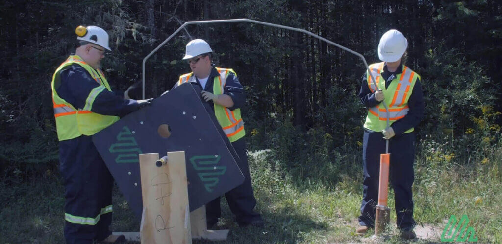
Using piezometers to determine pore pressure is essential to understand how subsurface ground responds to changes in geotechnical contexts. Because unsaturated and saturated soils of the same type have markedly different properties (especially under heavy loads), it is important that engineers are able to accurately measure groundwater levels, track water flow through the earth, and monitor water levels in standpipes.
Vertical ShapeArray installations can capture real-time deformation measurements as affected areas begin to shift in the time prior to slope instability. ShapeArray along with pore pressure data can create data sets that can inform design decisions. For example, rainfall and ground saturation data can be used to improve drainage designs. Similar data sets can determine alarm thresholds during operation.
Design engineers and engineers of record can check their design assumptions against observable measurements, ensuring that field performance of the structures behave as expected. Even during the design phase, norms and thresholds can be established to ensure that risks have not only been assessed but will continue to be assessed throughout the lifespan of the project.
Engineers need to:
· Measure risk and assess what alarm levels are appropriate
· Consider and develop what an acceptable response is if alarm thresholds are met
· Ensure a proper alarm system exists to warn stakeholders of the situation should these thresholds be reached
Proper instrumentation in place during both the design phase and throughout the mine’s operating lifespan, allows operators to be able to:
· Better understand soil response and how it changes over time and seasons
· Better maintain their structures
· Better plan maintenance activities
· Improve future risk assessments for new structures on or adjacent to instrumented sites. Increase confidence in designs implemented on site.
A proactive approach to risk mitigation will help increase productivity, protect human safety, and conform to legal and environmental regulations. And it provides clients with the peace of mind that the design is working the way that it is expected to work.